Worldwide Soaring Turnpoint Exchange

Unofficial Coordinates for the Husbands Bosworth, Leicestershire, United Kingdom Control Points


Contest: 4th Junior World Gliding Championships, 2005

Courtesy of 2005 Junior World Gliding Championships ( webmaster@worldgliding2005.com )
Dated: 30 July, 2004

Updated: 24 July, 2005

Time zone: GB-Eire, summer offset from GMT is 1:00 and in winter it is 0:00.

The waypoint data are available directly at www.worldgliding2005.com/points.php

Information about the 4th Junior World Gliding Championships, 2005 is available at www.worldgliding2005.com

The primary specification of the control point coordinates is degrees and decimal minutes


Copyright 2005 Junior World Gliding Championships
Version 2005a


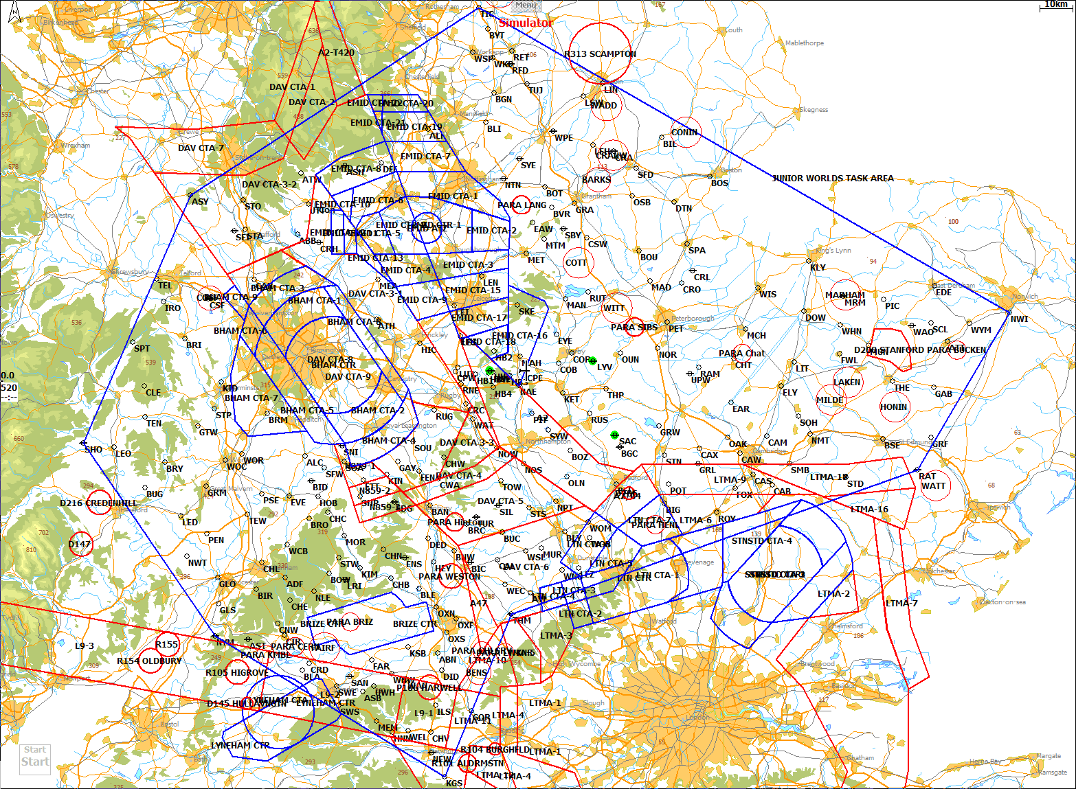
A map of the task area is available
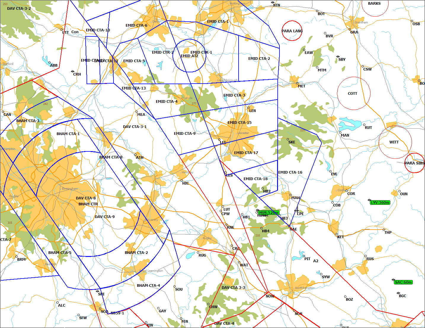
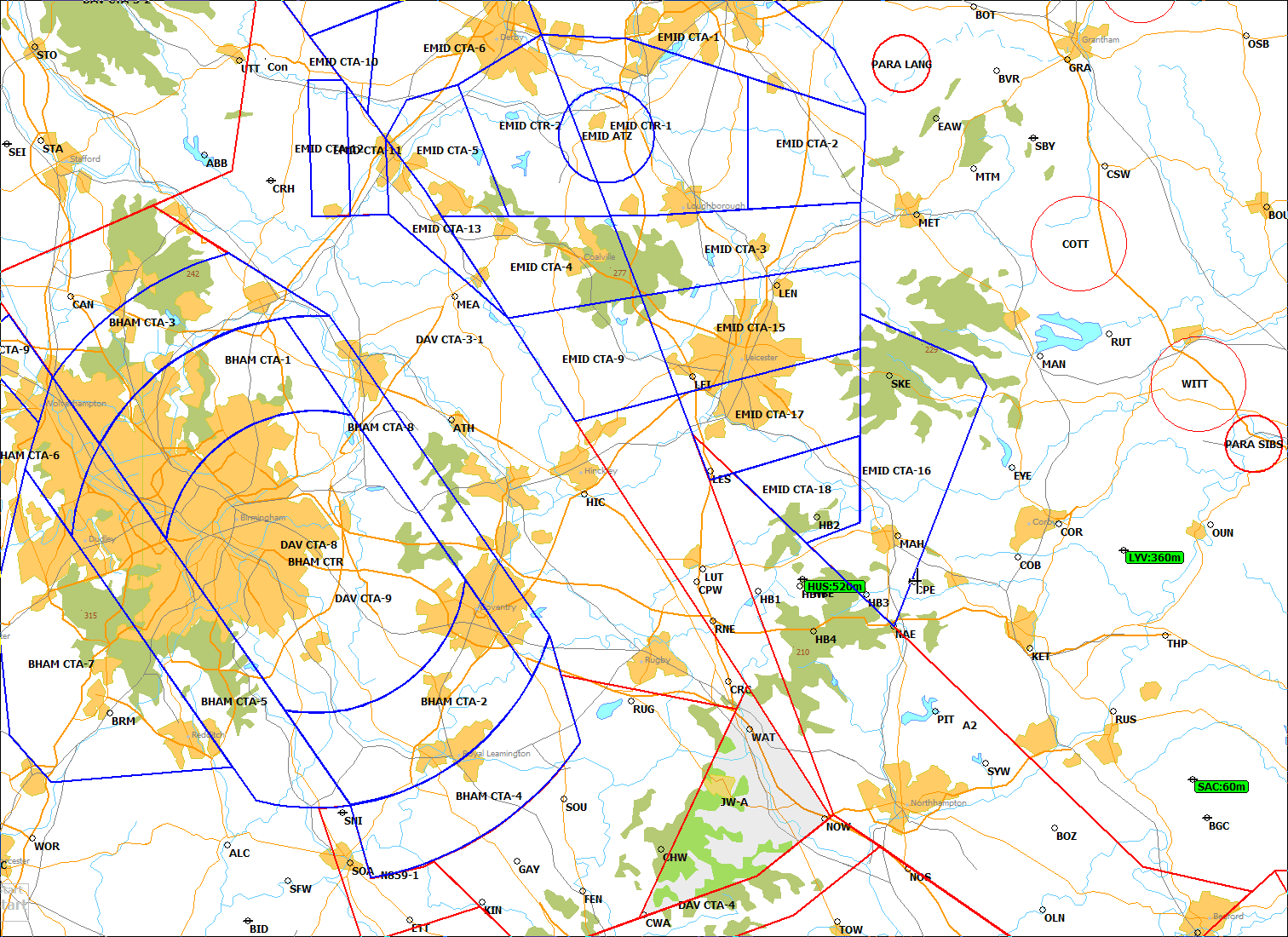
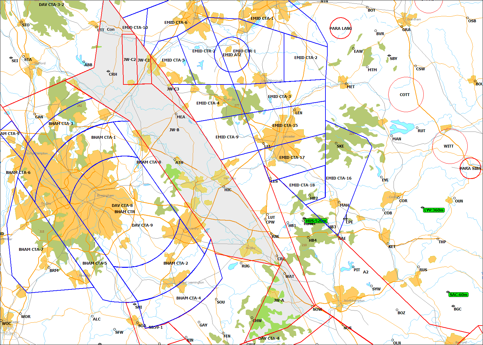
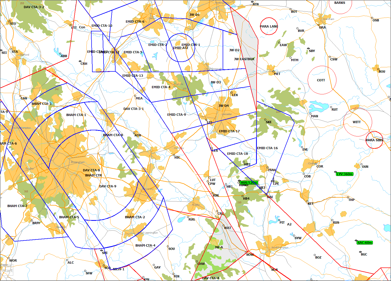
Maps of the restricted airspace are available: all airspace without any exemptions, all airspace with "Daventry Box" activated, all airspace with "Daventry Box" and "Birmingham Corridor" activated and all airspace with "Daventry Box" and "Midlands Eastern Box" activated.


UNOFFICIAL, USE AT YOUR OWN RISK

Do not use for navigation, for flight verification only.

Always consult the relevant publications for current and correct
information. This service is provided free of charge with no warrantees,
expressed or implied.
User assumes all risk of use.

Use is subject to these conditions.


_______________________________________________________________________________________________________________________________________________________________________________________________________________________________________________________________________________________________________________________________________________________________________________________________________________________________________________________________________________________________________________________________________________________________________________________________________________________________________________________________________________________

   ID  NumberName                           Codes      Links       Latitude    Longitude        Latitude     Longitude   Elevation      ID  ICAO    Frequency    Comments                                                                                                                                                                                          R/W Direction   R/W Length  R/W Surface
                                                                   °  '  "      °  '  "         °   '         °   '         Feet              ID                                                                                                                                                                                                                                                              
_______________________________________________________________________________________________________________________________________________________________________________________________________________________________________________________________________________________________________________________________________________________________________________________________________________________________________________________________________________________________________________________________________________________________________________________________________________________________________________________________________________________

  1  Abbot's Bromley                 T     Q,I,S,O,G      52 48 47 N    1 54 35 W  or  52 48.780 N    1 54.591 W      328     ABB          Reservoir/B5013 E                                  39       306                 E end of B5013 crossing water, 1.5 NMl W of town.  P-L. Easy to find and on chart.                                                                                                                                                        
  2  Abingdon Bridge                 T     Q,I,S,O,G      51 40 07 N    1 16 46 W  or  51 40.120 N    1 16.765 W      269     ABN          A415 br over River Thames                          47       191                 SE side of town just S of church tower.  Small island is in middle of bridge.  Avoids Abingdon airfield parachuting zone. Easy to find and on chart.                                                                                      
  3  Andoversford                    T     Q,I,S,O,G      51 52 33 N    1 57 51 W  or  51 52.545 N    1 57.850 W      187     ADF          A436/A40                                           48       225                 Most N of two T junctions near village centre. P-L. Easy to find and on chart.                                                                                                                                                            
  4  Alcester                        T     Q,I,S,O,G      52 12 26 N    1 52 38 W  or  52 12.435 N    1 52.640 W      148     ALC          River/A46                                          34       246                 Br. over R. Arrow SSW edge of town, between two rbts. P-L. Easy to find and on chart.                                                                                                                                                     
  5  Alfreton                        T     Q,I,S,O,G      53 06 04 N    1 19 28 W  or  53 06.070 N    1 19.465 W      253     ALF          M1 J28/A38                                         41       346                 2 NMl E of town, towards Mansfield. Easy to find and on chart.                                                                                                                                                                            

  6  Ashbury                         T     Q,I,S,O,G      51 33 50 N    1 37 05 W  or  51 33.830 N    1 37.091 W      374     ASB          B4000/B4507                                        57       202                 Main crossroads in village centre, 2.5 NMl SE of Shrivenham. Difficult to find.                                                                                                                                                           
  7  Ashbourne                       AT    Q,I,S,O,G      53 00 01 N    1 41 49 W  or  53 00.020 N    1 41.820 W      230     ASH          A/F SE end R/W 32                                  41       325                 Minor road across R/W 32 at SE end. P-L. Difficult to find.                                                                                                                                            10/32                              
  8  Aston Down                      AT    Q,I,S,O,G      51 42 21 N    2 07 55 W  or  51 42.355 N    2 07.915 W      600     AST          R/Ws 26/20                                         60       223       130.10    SW intersection at Cotswold GC site. P-L, ##. Difficult to find.                                                                                                                                       26/20                              
  9  Ashley                          T     Q,I,S,O,G      52 55 11 N    2 23 26 W  or  52 55.180 N    2 23.440 W      253     ASY          A53/B502                                           57       301                 W of 2 T junctions, W edge of town, 7 NMl SW of Stoke-on-Trent. Difficult to find.                                                                                                                                                        
 10  Atherstone                      T     Q,I,S,O,G      52 34 49 N    1 33 14 W  or  52 34.820 N    1 33.236 W      318     ATH          A5/Rail Bridge                                     20       295                 NW edge of town, near canal. Easy to find and on chart.                                                                                                                                                                                   

 11  Attleborough                    T     Q,I,S,O,G      52 31 17 N    1 00 38 E  or  52 31.276 N    1 00.635 E      164     ATT          A11 Br over B1077                                  75        86                 N side of town, 10 NMl ENE of Thetford. Easy to find and on chart.                                                                                                                                                                        
 12  Alton Towers                    T     Q,I,S,O,G      52 58 50 N    1 53 40 W  or  52 58.830 N    1 53.670 W      217     ATW          River/Road Bridge                                  45       317                 Br over river Churnet between theme park & village. P-L. Difficult to find.                                                                                                                                                               
 13  Aylesbury                       T     Q,I,S,O,G      51 49 59 N    0 51 46 W  or  51 49.990 N    0 51.771 W      289     AYL          A41/Rail Bridge                                    37       169                 Bridge over A41 2.5 NMl NW of town. P-L. Easy to find and on chart.                                                                                                                                                                       
 14  Banbury                         T     Q,I,S,O,G      52 04 21 N    1 18 47 W  or  52 04.355 N    1 18.781 W      308     BAN          M40 J11/A422                                       24       204                 1.5 NMl NE of town Centre. P-L. Easy to find and on chart.                                                                                                                                                                                
 15  Bedford Bridge                  T     Q,I,S,O,G      52 07 47 N    0 28 39 W  or  52 07.785 N    0 28.645 W       98     BED          River/Rail Br                                      28       132                 W of 2 rail br over River Great Ouse, near W of 2 rbts.  P-L. Difficult to find.                                                                                                                                                          

 16  Bedford Airfield                AT    Q,I,S,O,G      52 13 51 N    0 27 47 W  or  52 13.846 N    0 27.785 W      293     BGC          R/Ws 27/24                                         25       120       130.00    Most E of three intersections, half way along main 10,500 ft R/W 24/06 Bedford GC site, at disused airfield. P-L, ##. Difficult to find.                                                               06/27              10490  A        
 17  Boughton                        T     Q,I,S,O,G      53 12 03 N    1 01 37 W  or  53 12.056 N    1 01.620 W      197     BGN          A614/A616/A6075                                    46         1                 Roundabout W side of village at Ollerton, joining many roads. Easy to find and on chart.                                                                                                                                                  
 18  Bicester Control Tower          AT    Q,I,S,O,G,L,W  51 54 56 N    1 08 12 W  or  51 54.935 N    1 08.195 W      267     BIC  EGDD    Control Tower                                      32       186                 W side of grass airfield site of RAF Bicester Club, NE side of town. P-L, ##. Easy to find and on chart.                                                                                                                                  
 19  Bidford                         AT    Q,I,S,O,G      52 08 26 N    1 50 51 W  or  52 08.425 N    1 50.850 W      135     BID          Hangar                                             34       239       130.10    N side of grass A/F, Bidford Soaring Centre site. P-L, ##. Local knowledge required.                                                                                                                                                      
 20  Biggleswade                     T     Q,I,S,O,G      52 04 38 N    0 15 40 W  or  52 04.636 N    0 15.660 W       98     BIG          A1/Rail Bridge                                     36       127                 Dual Carriageway br S of stn on S edge of town. P-L. Easy to find and on chart.                                                                                                                                                           

 21  Billinghay                      T     Q,I,S,O,G      53 04 42 N    0 16 26 W  or  53 04.695 N    0 16.430 W      105     BIL          A153/B1189                                         47        36                 T juntion E side of village, RAF Coningsby 4 Ml to the E, avoid. Difficult to find.                                                                                                                                                       
 22  Birdlip                         T     Q,I,S,O,G      51 50 37 N    2 05 43 W  or  51 50.621 N    2 05.720 W      751     BIR          A417/A436/B4070                                    53       228                 Rbt at top of hill, avoids possible sea air in Severn valley. P-L. Easy to find and on chart.                                                                                                                                             
 23  Blakehill Farm                  T     Q,I,S,O,G      51 37 20 N    1 53 21 W  or  51 37.330 N    1 53.350 W      310     BLA          Concrete Plinth                                    58       213                 Centre of disused grass airfield. Plinth was for tall mast, now removed. P-L. Easy to find and on chart.                                                                                                                                  
 24  Blenheim                        T     Q,I,S,O,G      51 50 40 N    1 21 52 W  or  51 50.670 N    1 21.865 W      331     BLE          Palace Grand Bridge                                38       198                 400 m NW of palace between two lakes. On NW edge of Kidlington ATZ, site of a busy flying training school. P-L, #. Easy to find but not on chart.                                                                                         
 25  Blidworth                       T     Q,I,S,O,G      53 07 12 N    1 03 49 W  or  53 07.205 N    1 03.820 W      230     BLI          A617/A614 R'bout                                   41       359                 Roundabout 2 NMl NE of village, 9 NMl NNE of Nottingham. Easy to find and on chart.                                                                                                                                                       

 26  Bletchley                       T     Q,I,S,O,G      52 00 03 N    0 42 31 W  or  52 00.055 N    0 42.525 W      299     BLY          Rail Bridge/A5                                     29       155                 E of town near River Ouzel & Grand Union Canal. P-L. Easy to find and on chart.                                                                                                                                                           
 27  Bicester North West             T     Q,I,S,O,G      51 56 54 N    1 12 19 W  or  51 56.905 N    1 12.315 W      413     BNW          M40 J 10/ B 430                                    30       191                 M40 bridge between 2 roundabouts, NE side of Ardley village.  3 NMl NNW of Bicester town. P-L. Easy to find and on chart.                                                                                                                 
 28  Boston                          T     Q,I,S,O,G      52 58 19 N    0 03 32 W  or  52 58.315 N    0 03.530 W       92     BOS          A52 Br. over dyke                                  48        48                 SW edge of town, 1 NMl E of Boston Airfield. Easy to find and on chart.                                                                                                                                                                   
 29  Bottesford                      T     Q,I,S,O,G      52 56 36 N    0 48 01 W  or  52 56.605 N    0 48.011 W      154     BOT          Church Spire                                       31        16                 Centre of village. Difficult to find.                                                                                                                                                                                                     
 30  Bourne                          T     Q,I,S,O,G      52 46 05 N    0 22 38 W  or  52 46.080 N    0 22.635 W      154     BOU          A15/A151                                           31        51                 Town Centre. Difficult to find.                                                                                                                                                                                                           

 31  Bourton-on-the-Water            T     Q,I,S,O,G      51 53 12 N    1 46 07 W  or  51 53.200 N    1 46.110 W      194     BOW          A429/River Bridge                                  43       219                 Bridge over River Windrush just W of village. P-L. Difficult to find.                                                                                                                                                                     
 32  Bozeat                          T     Q,I,S,O,G      52 13 19 N    0 41 02 W  or  52 13.310 N    0 41.035 W      154     BOZ          Road Br over A 509                                 19       134                 W side of village, A509 runs N/S, bridge is E/W. Easy to find but not on chart.                                                                                                                                                           
 33  Brackley South                  T     Q,I,S,O,G      52 01 16 N    1 08 57 W  or  52 01.270 N    1 08.956 W      322     BRC          A43/A422 r'bout                                    25       189                 S side of town, used as start point by Aquila club.  High radiation to the SW (Croughton), parachuting at Hinton to the West. Easy to find and on chart.                                                                                  
 34  Bridgnorth                      T     Q,I,S,O,G      52 31 40 N    2 25 02 W  or  52 31.660 N    2 25.041 W      200     BRI          River/A458 Bridge                                  50       276                 Southern of two bridges over River Severn, S side of town. P-L. Easy to find and on chart.                                                                                                                                                
 35  Bromsgrove                      T     Q,I,S,O,G      52 19 22 N    2 02 47 W  or  52 19.360 N    2 02.776 W      144     BRM          Station Bridge NE                                  37       259                 Road bridge NE end of stn.  SE edge of Town. P-L. Difficult to find.                                                                                                                                                                      

 36  Broadway                        T     Q,I,S,O,G      52 02 11 N    1 51 21 W  or  52 02.180 N    1 51.355 W      161     BRO          A44/B4632 East                                     38       231                 East of 2 T junctions where Stratford road leaves A44. P-L. Difficult to find.                                                                                                                                                            
 37  Bromyard                        T     Q,I,S,O,G      52 11 28 N    2 30 20 W  or  52 11.460 N    2 30.340 W      230     BRY          Church Tower                                       56       255                 NE Side of town. P-L. Difficult to find.                                                                                                                                                                                                  
 38  Bury St Edmunds                 T     Q,I,S,O,G      52 15 12 N    0 43 15 E  or  52 15.195 N    0 43.251 E      187     BSE          Rail Br/A14                                        66        99                 Br where Ipswich line passes over A14, NE side of town. P-L. Easy to find and on chart.                                                                                                                                                   
 39  Buckingham                      T     Q,I,S,O,G      51 59 53 N    0 59 20 W  or  51 59.885 N    0 59.335 W      420     BUC          Church Spire                                       27       175                 In Town Centre. P-L. Difficult to find.                                                                                                                                                                                                   
 40  Burley Gate                     T     Q,I,S,O,G      52 07 15 N    2 35 46 W  or  52 07.251 N    2 35.760 W      259     BUG          A417/A465                                          60       252                 Roundabout SW side of village. Easy to find and on chart.                                                                                                                                                                                 

 41  Belvoir                         T     Q,I,S,O,G      52 53 15 N    0 46 02 W  or  52 53.245 N    0 46.035 W      138     BVR          Bridge over Castle Lake                            29        21                 1 NMl SE of Belvoir Castle, SW side of Woolsthorpe Village. P-L. Easy to find but not on chart.                                                                                                                                           
 42  Blyth                           T     Q,I,S,O,G      53 22 31 N    1 03 13 W  or  53 22.525 N    1 03.221 W      151     BYT          A1 Bridge over A634                                56       360                 E side of town, 13 NMl E of Sheffield. Easy to find and on chart.                                                                                                                                                                         
 43  Cambridge SE                    T     Q,I,S,O,G      52 07 45 N    0 13 19 E  or  52 07.750 N    0 13.325 E       95     CAB          A11/A1307 R'bout                                   50       111                 Between  Babraham  and Little Abington, 4nml NE of Duxford airfield. LTMA based 3500ft 2nml to the South. Easy to find and on chart.                                                                                                      
 44  Calvert Rail Junction           T     Q,I,S,O,G      51 55 28 N    1 00 41 W  or  51 55.470 N    1 00.690 W      279     CAL          Bridge W side of Rail Junction                     31       178                 Road br. over rly W side of triangle rail junction, 5 E of Bicester. P-L. Difficult to find.                                                                                                                                              
 45  Cambridge North                 T     Q,I,S,O,G      52 15 44 N    0 11 48 E  or  52 15.735 N    0 11.805 E       85     CAM          Rail/road                                          47       103                 Level crossing 100m SW of Waterbeach station, W of river Cam. Difficult to find.                                                                                                                                                          

 46  Cannock                         T     Q,I,S,O,G      52 41 20 N    2 06 13 W  or  52 41.340 N    2 06.210 W      266     CAN          M6 J12/A5                                          41       292                 3.5 NMl W of town, 15 NMl NW of Birmingham. P-L. Easy to find and on chart.                                                                                                                                                               
 47  Cambridge South                 T     Q,I,S,O,G      52 09 24 N    0 08 07 E  or  52 09.395 N    0 08.115 E       95     CAS          Rail Fork                                          47       111                 Y shaped rail junction N side of Great Shelford village. P-L. Easy to find and on chart.                                                                                                                                                  
 48  Cambridge West                  T     Q,I,S,O,G      52 12 52 N    0 04 41 E  or  52 12.865 N    0 04.680 E       72     CAW          M11 J13/A1303                                      43       108                 A1303 Br. over M11, W edge of city.   Other flyovers 1.5 NMl S and 1 Nml N. A1303 becomes A45 & goes W to Bourn A/F. Difficult to find.                                                                                                   
 49  Caxton Gibbet                   T     Q,I,S,O,G      52 13 43 N    0 06 13 W  or  52 13.716 N    0 06.215 W      220     CAX          A45/A1198 R'bout                                   37       110                 N of Caxton village. P-L. Easy to find and on chart.                                                                                                                                                                                      
 50  Charlbury                       T     Q,I,S,O,G      51 52 23 N    1 29 28 W  or  51 52.381 N    1 29.460 W      433     CHB          B4437 Br over rail                                 38       206                 W side of village just W of River Evenlode. P-L. Difficult to find.                                                                                                                                                                       

 51  Chipping Campden                T     Q,I,S,O,G      52 03 11 N    1 46 30 W  or  52 03.180 N    1 46.505 W      167     CHC          Church Twr                                         35       229                 N end of village near B4035/B4081 T junction. P-L. Difficult to find.                                                                                                                                                                     
 52  Chedworth                       T     Q,I,S,O,G      51 48 45 N    1 56 35 W  or  51 48.746 N    1 56.575 W      827     CHE          R/W 21/Road Crossing                               50       222                 Disused airfield, minor road crossing SW runway. Difficult to find.                                                                                                                                                                       
 53  Cheltenham                      T     Q,I,S,O,G      51 54 58 N    2 04 12 W  or  51 54.960 N    2 04.200 W      230     CHL          A435/B4075                                         49       230                 Roundabout SW side of Racecourse. P-L. Easy to find and on chart.                                                                                                                                                                         
 54  Chipping Norton                 T     Q,I,S,O,G      51 57 07 N    1 31 29 W  or  51 57.121 N    1 31.481 W      751     CHN          A3400/A361 R'bout                                  34       211                 1 NMl NE of village. P-L. Easy to find and on chart.                                                                                                                                                                                      
 55  Chatteris                       T     Q,I,S,O,G      52 28 26 N    0 03 05 E  or  52 28.435 N    0 03.080 E       20     CHT          A141/ River Bridge                                 40        87                 1 NMl N of town. Easy to find and on chart.                                                                                                                                                                                               

 56  Chieveley                       T     Q,I,S,O,G      51 27 09 N    1 18 38 W  or  51 27.155 N    1 18.625 W      361     CHV          M4 J13 Roundabout                                  60       189                 Just East of M4 bridge over A34 Near Motorway Services. P-L. Easy to find and on chart.                                                                                                                                                   
 57  Charwelton                      T     Q,I,S,O,G      52 12 10 N    1 15 04 W  or  52 12.170 N    1 15.061 W      230     CHW          Tower                                              16       208                 388 ft tower 1.5 NMl W of village, 5 NMl SW of Daventry. P-L. Difficult to find.                                                                                                                                                          
 58  Cirencester Church              T     Q,I,S,O,G      51 43 02 N    1 58 05 W  or  51 43.040 N    1 58.075 W      331     CIR          Church Tower                                       55       218                 Church with tower N of Town Centre in line with A417, E of small lake. P-L. Difficult to find.                                                                                                                                            
 59  Clee                            T     Q,I,S,O,G      52 23 53 N    2 35 49 W  or  52 23.876 N    2 35.815 W     1750     CLE          Hill Radar N Dome                                  57       268                 Most N Dome nr 1750 ft summit.  4 NMl ENE of Ludlow. P-L. Difficult to find.                                                                                                                                                              
 60  Cirencester NW                  T     Q,I,S,O,G      51 44 58 N    1 59 54 W  or  51 44.970 N    1 59.900 W      322     CNW          A417 r'bout NW                                     54       221                 Centre of A417 between two small roundabouts S of quarry , 3 NW Cirencester.  Gives stand-off for rounding Brize Zone. Easy to find and on chart.                                                                                         

 61  Corby South                     T     Q,I,S,O,G      52 27 35 N    0 44 13 W  or  52 27.581 N    0 44.220 W      302     COB          A6003/A6014 Rbt                                    11        84                 Roundabout at Y shape of roads SSW edge of town, leading to dual carriageway to Kettering. Easy to find and on chart.                                                                                                                     
 62  Corby                           T     Q,I,S,O,G      52 29 22 N    0 40 38 W  or  52 29.365 N    0 40.625 W      315     COR          A427/A6116                                         14        78                 E side of Town, 0.5km NE of 2 small lakes, P-L. Difficult to find.                                                                                                                                                                        
 63  Control East                    T     Q,I,O,G        52 26 18 N    0 53 12 W  or  52 26.300 N    0 53.200 W      505     CPE                                                            5.9        91                                                                                                                                                                                                                                                           
 64  Control West                    T     Q,I,O,G        52 26 18 N    1 12 00 W  or  52 26.300 N    1 12.000 W      505     CPW                                                            5.6       269                                                                                                                                                                                                                                                           
 65  Cranwell North                  AT    Q,I,S,O,G,L,W  53 02 23 N    0 29 26 W  or  53 02.385 N    0 29.435 W      220     CRA  EGYD    A/F Hangars                                        41        29       125.05    S side of grass airfield next to military A/F with MATZ and jets and light aircraft 7 days per week.  Site of Cranwell RAFGSA Club, ##. Local knowledge required.                                      09/01               6820  A        

 66  Crick                           T     Q,I,S,O,G      52 21 02 N    1 09 17 W  or  52 21.040 N    1 09.275 W      276     CRC          M1 J18/A428                                       6.7       216                 1 km NNW of village.  6 N of Daventry. P-L. Easy to find and on chart.                                                                                                                                                                    
 67  Cricklade                       T     Q,I,S,O,G      51 38 25 N    1 51 27 W  or  51 38.410 N    1 51.445 W      259     CRD          Church Tower                                       57       212                 Town centre near B4040/B4553 junction. Difficult to find.                                                                                                                                                                                 
 68  Cross Hayes                     AT    Q,I,S,O,G      52 47 29 N    1 48 52 W  or  52 47.475 N    1 48.860 W      320     CRH          Gliding Club Hangar                                35       307       130.10    Site of Needwood Forest GC on SW edge of Tatenhill ATZ, ##. Local knowledge required.                                                                                                                                                     
 69  Crowland A/F                    AT    Q,I,S,O,G      52 42 49 N    0 08 10 W  or  52 42.820 N    0 08.170 W       10     CRL          A/F E end, by A1073                                37        63       130.10    Peterborough & Spalding GC site, also light aircraft, ##. Local knowledge required.                                                                                                                                                       
 70  Crowland Bridge                 T     Q,I,S,O,G      52 40 46 N    0 11 01 W  or  52 40.770 N    0 11.010 W       13     CRO          River/B1166                                        35        65                 Over River Welland 1 NMl W of Town. Easy to find and on chart.                                                                                                                                                                            

 71  Cosford Airfield                AT    Q,I,S,O,G,L,W  52 38 15 N    2 18 44 W  or  52 38.250 N    2 18.740 W      271     CSF  EGWC    R/W 24 SW end                                      48       285       128.82    Military airfield with ATZ, mainly light aircraft traffic.  Site of Wrekin RAFGSA Club. P-L, ##. Easy to find and on chart.                                                                            06/24               3830  A        
 72  Colsterworth                    T     Q,I,S,O,G      52 48 12 N    0 36 39 W  or  52 48.205 N    0 36.655 W      262     CSW          A1/A151 R'bout                                     27        36                 SE side of village, 6 NMl S of Grantham. P-L. Easy to find and on chart.                                                                                                                                                                  
 73  Chipping Warden                 T     Q,I,S,O,G      52 08 43 N    1 16 34 W  or  52 08.720 N    1 16.566 W      256     CWA          R/Ws 24/36                                         20       205                 Most N intersection of old r/ws at disused airfield. P-L. Difficult to find.                                                                                                                                                              
 74  Deddington                      T     Q,I,S,O,G      51 58 55 N    1 19 23 W  or  51 58.925 N    1 19.380 W      417     DED          A 4260 / B 4031                                    29       200                 Village centre, just W of church with Tower. P-L. Easy to find and on chart.                                                                                                                                                              
 75  Duffield                        T     Q,I,S,O,G      53 00 28 N    1 32 05 W  or  53 00.461 N    1 32.080 W      194     DFF          B5023/River Br                                     38       333                 Nr rly 2 NMl NW of town.  CTA base 2500 2 NML to S. Difficult to find.                                                                                                                                                                    

 76  Didcot                          T     Q,I,S,O,G      51 37 18 N    1 15 39 W  or  51 37.295 N    1 15.655 W      190     DID          Power Stn Chimney                                  50       189                 The only tall, thin Chimney among several cooling towers. P-L. Easy to find and on chart.                                                                                                                                                 
 77  Downham Market                  T     Q,I,S,O,G      52 36 15 N    0 21 54 E  or  52 36.246 N    0 21.905 E       72     DOW          Station                                            52        79                 W side of town 300 m NE of Great Ouse river bridge. P-L. Difficult to find.                                                                                                                                                               
 78  Donington                       T     Q,I,S,O,G      52 54 06 N    0 13 04 W  or  52 54.095 N    0 13.060 W      102     DTN          A52/Rail Bridge                                    41        47                 W of village. Easy to find and on chart.                                                                                                                                                                                                  
 79  Earith                          T     Q,I,S,O,G      52 21 14 N    0 02 16 E  or  52 21.225 N    0 02.265 E       46     EAR          A1123/River Br                                     40        97                 W of two river bridges on E side of village. P-L. Difficult to find.                                                                                                                                                                      
 80  Eastwell                        T     Q,I,S,O,G      52 50 44 N    0 51 17 W  or  52 50.725 N    0 51.285 W      161     EAW          Crossroads                                         25        16                 0.4 Nml SW of village 6NMl NNE of Melton Mobwray, on road from Waltham to Harby.  For 300 k from Gransden. Local knowledge required.                                                                                                      

 81  East Dereham                    T     Q,I,S,O,G      52 40 20 N    0 56 59 E  or  52 40.331 N    0 56.990 E      164     EDE          A47 Br over Rly                                    74        78                 Disused railway S side of town, 4 NMl S of Swanton A/F. Difficult to find.                                                                                                                                                                
 82  Edgehill                        AT    Q,I,S,O,G      52 04 55 N    1 28 29 W  or  52 04.910 N    1 28.485 W      642     EDG          A/F R/Ws 17/23                                     27       216       130.10    Site of Shenington GC. P-L, ##. Easy to find and on chart.                                                                                                                                             17/23               2620  G        
 83  Ely                             T     Q,I,S,O,G      52 23 53 N    0 15 50 E  or  52 23.885 N    0 15.835 E       79     ELY          Cathedral Tower                                    48        93                 Centre of town. P-L. Easy to find but not on chart.                                                                                                                                                                                       
 84  Enstone                         AT    Q,I,S,O,G      51 55 45 N    1 25 44 W  or  51 55.755 N    1 25.730 W      550     ENS          Control Tower                                      34       205       129.87    S of midpoint of main R/W with light aircraft activity. Site of Oxfordshire Sportflying (BGA member).  P-L, ##. Easy to find and on chart.                                                             08/26               3600  A        
 85  Ettington                       T     Q,I,S,O,G      52 08 29 N    1 36 50 W  or  52 08.480 N    1 36.840 W      164     ETT          A429/A422 R'bout                                   27       229                 NW of village, 1 NMl NW of Fosse Way. 5 SE Stratford. P-L. Easy to find and on chart.                                                                                                                                                     

 86  Evesham                         T     Q,I,S,O,G      52 05 53 N    1 56 45 W  or  52 05.890 N    1 56.755 W       98     EVE          Station/Road Br E                                  39       238                 Br over rly just E of stn, NW side of Town. P-L. Difficult to find.                                                                                                                                                                       
 87  Eyebrook                        T     Q,I,S,O,G      52 32 20 N    0 44 42 W  or  52 32.335 N    0 44.695 W      315     EYE          Reservoir Dam SW                                   13        62                 SW end of dam wall, S side of water. 3 NMl N of Corby. P-L. Easy to find and on chart.                                                                                                                                                    
 88  Faringdon                       T     Q,I,S,O,G      51 38 57 N    1 34 31 W  or  51 38.955 N    1 34.516 W      390     FAR          A420/A417 R'bout                                   51       203                 Roundabout SE side of town. Brize Zone 2 NMl N. P-L. Difficult to find.                                                                                                                                                                   
 89  Fenny Compton                   T     Q,I,S,O,G      52 10 00 N    1 21 51 W  or  52 09.995 N    1 21.855 W      240     FEN          A423 Br over rail                                  20       215                 1 NMl E of village, canal immediately to the north. P-L. Easy to find and on chart.                                                                                                                                                       
 90  Foxton                          T     Q,I,S,O,G      52 07 08 N    0 03 21 E  or  52 07.140 N    0 03.355 E      121     FOX          Rail /A10                                          45       115                 Just W of Foxton Station, 3 NMl NW of Duxford A/F. P-L. Easy to find and on chart.                                                                                                                                                        

 91  Feltwell                        T     Q,I,S,O,G      52 29 15 N    0 31 29 E  or  52 29.255 N    0 31.490 E       56     FWL          Church Tower                                       58        87                 NE side of village near B1112/B1386 junction. Difficult to find.                                                                                                                                                                          
 92  Garboldisham                    T     Q,I,S,O,G      52 23 43 N    0 56 49 E  or  52 23.710 N    0 56.815 E      161     GAB          A1066/B1111(E)                                     73        91                 E of two T junctions in village centre. 7 NMl E of Thetford. Easy to find and on chart.                                                                                                                                                   
 93  Gaydon                          T     Q,I,S,O,G      52 11 33 N    1 27 32 W  or  52 11.556 N    1 27.535 W      203     GAY          M40 J12/B4451                                      21       226                 2 NMl NE of centre of disused A/F with one long rwy. P-L. Easy to find and on chart.                                                                                                                                                      
 94  Gloucester West                 T     Q,I,S,O,G      51 52 30 N    2 16 04 W  or  51 52.500 N    2 16.066 W      121     GLO          A40/River B                                        56       233                 W of A40/A417 Rbt, N of 3 brs. over R. Severn, W of city. P-L. Difficult to find.                                                                                                                                                         
 95  Gloucester South                T     Q,I,S,O,G      51 48 15 N    2 15 53 W  or  51 48.250 N    2 15.885 W      112     GLS          Rail/M5 Bridge                                     59       230                 1 NMl E of M5 Junction 12. 3 NMl SSW of Gloucester. P-L. Easy to find and on chart.                                                                                                                                                       

 96  Goring                          T     Q,I,S,O,G      51 30 42 N    1 07 41 W  or  51 30.695 N    1 07.680 W      226     GOR          Rail/River bridge                                  56       183                 Rail br over R. Thames 1 NMl S of town.  8 NW of Reading. P-L. Easy to find and on chart.                                                                                                                                                 
 97  Grantham                        T     Q,I,S,O,G      52 53 50 N    0 39 53 W  or  52 53.841 N    0 39.875 W      210     GRA          A1/A607                                            31        27                 SW of town, close to canal bridge. Easy to find and on chart.                                                                                                                                                                             
 98  Great Ashfield                  T     Q,I,S,O,G      52 15 26 N    0 56 09 E  or  52 15.425 N    0 56.150 E      200     GRF          A/F R/Ws 24/31                                     73        98                 Disused A/F, 8 NMl N of Wattisham airfield. Difficult to find.                                                                                                                                                                            
 99  Gransden Lodge                  AT    Q,I,S,O,G      52 11 11 N    0 06 40 W  or  52 11.176 N    0 06.671 W      254     GRL          Clubhouse                                          38       114       130.10    N side of Cambridge GC site. Avoid Fuller's Hill grass airfield [Little Gransden' on ICAO map] 1 NMl SW with light aircraft & microlights, including aerobatics. P-L, ##. Local knowledge required.    09/27               3240  G        
100  Great Malvern                   T     Q,I,S,O,G      52 07 30 N    2 19 09 W  or  52 07.500 N    2 19.145 W      203     GRM          Station/A449                                       50       248                 A449 Bridge S side of N of 2 stations in Malvern. P-L. Difficult to find.                                                                                                                                                                 

101  Grafham Water                   T     Q,I,S,O,G      52 17 23 N    0 17 11 W  or  52 17.385 N    0 17.176 W      200     GRW          SE Tower                                           29       108                 Tower in water by dam on SE side of lake. P-L. Easy to find but not on chart.                                                                                                                                                             
102  Great Witley                    T     Q,I,S,O,G      52 17 20 N    2 21 25 W  or  52 17.340 N    2 21.415 W      210     GTW          A443/B4197                                         49       260                 T junction SE of village, 1 NMl S of 930 ft spot height. Difficult to find.                                                                                                                                                               
103  Husbands Bosworth 1 Start W     S     Q,I,O,G        52 25 48 N    1 06 42 W  or  52 25.800 N    1 06.700 W      505     HB1                                                            2.5       255                                                                                                                                                                                                                                                           
104  Husbands Bosworth 2 Start N     S     Q,I,O,G        52 29 42 N    1 01 36 W  or  52 29.700 N    1 01.600 W      505     HB2                                                            3.3        13                                                                                                                                                                                                                                                           
105  Husbands Bosworth 3 Start E     S     Q,I,O,G        52 25 36 N    0 57 18 W  or  52 25.600 N    0 57.300 W      505     HB3                                                            3.5       104                                                                                                                                                                                                                                                           

106  Husbands Bosworth 4 Start S     S     Q,I,O,G        52 23 42 N    1 01 54 W  or  52 23.700 N    1 01.900 W      505     HB4          A5199 bridge over A14                             2.8       168                 Centre of bridge over dual carriageway, 3 Nml S of Husband's Bosworth gliding site.  1.5 NML W of Naseby village NW of small reservoir. Easy to find and on chart.                                                                        
108  Husbands Bosworth Finish West   F     Q,I,O,G        52 26 05 N    1 03 04 W  or  52 26.090 N    1 03.060 W      505     HBW                                                            0.4       203       130.10                                                                                                                                                                                                           09/27               3240  G        
109  Heyford Station                 T     Q,I,S,O,G      51 55 07 N    1 17 58 W  or  51 55.111 N    1 17.971 W      417     HEY          B4030 Br over Rail                                 33       197                 2 NMl SW of the centre of Upper Heyford disused A/F. P-L. Easy to find and on chart.                                                                                                                                                      
110  Hinckley                        T     Q,I,S,O,G      52 30 54 N    1 21 41 W  or  52 30.900 N    1 21.685 W      299     HIC          M69 J1/A5                                          12       291                 1 NMl S of town. P-L. Easy to find and on chart.                                                                                                                                                                                          
111  Hungerford North                T     Q,I,S,O,G      51 27 10 N    1 28 58 W  or  51 27.170 N    1 28.970 W      509     HNN          M4 J14/A338                                        61       195                 3 NMl NNE of town. P-L. Easy to find and on chart.                                                                                                                                                                                        

112  Honeybourne                     T     Q,I,S,O,G      52 05 49 N    1 48 57 W  or  52 05.815 N    1 48.950 W      171     HOB          Rail/Rail Bridge                                   35       234                 E/W line to Oxford crosses over old N/S line to Stratford.  P-L. Difficult to find.                                                                                                                                                       
113  Husbands Bosworth               HAT   Q,I,S,O,G      52 26 26 N    1 02 49 W  or  52 26.440 N    1 02.815 W      505     HUS          Centre of Hangar complex                                              130.10    Site of The Soaring Centre (ex-Coventry GC). N side of grass airfield. P-L, ##. Difficult to find.                                                                                                     09/27               3240  G        
114  Ilsley                          T     Q,I,S,O,G      51 31 30 N    1 17 27 W  or  51 31.500 N    1 17.455 W      390     ILS          Church Tower                                       56       189                 East Ilsley church, near village centre.  Just E of A34. P-L. Difficult to find.                                                                                                                                                          
115  Ironbridge                      T     Q,I,S,O,G      52 37 47 N    2 30 47 W  or  52 37.780 N    2 30.790 W      217     IRO          Power Stn Chimney                                  55       283                 Tallest Chimney. P-L. Easy to find and on chart.                                                                                                                                                                                          
116  Kettering                       T     Q,I,S,O,G      52 22 47 N    0 43 07 W  or  52 22.790 N    0 43.115 W      295     KET          A509 Br over Rail                                  13       107                 S side of town but N of A6/A604 dual carriageway. P-L. Easy to find but not on chart.                                                                                                                                                     

117  Kingsclere                      T     Q,I,S,O,G      51 19 47 N    1 15 01 W  or  51 19.785 N    1 15.015 W      295     KGS          A339 Roundabout                                    67       187                 N side of town, 6 Nml NW of Basingstoke. P-L. Difficult to find.                                                                                                                                                                          
118  Kidderminster                   T     Q,I,S,O,G      52 24 37 N    2 15 05 W  or  52 24.610 N    2 15.080 W      144     KID          B4189/River Br                                     44       268                 2 NMl N of town, middle of 3 br over canal & R.  Stour. P-L. Difficult to find.                                                                                                                                                           
119  Kingham                         T     Q,I,S,O,G      51 54 06 N    1 37 40 W  or  51 54.095 N    1 37.661 W      279     KIM          Rail/B4450                                         39       214                 Just S of Kingham station, 4 NMl ESE of Stow-on-the-Wold. P-L. Difficult to find.                                                                                                                                                         
120  Kineton                         T     Q,I,S,O,G      52 09 23 N    1 30 36 W  or  52 09.385 N    1 30.596 W      269     KIN          B4086/B4451                                        24       225                 Vill. centre, W of two T junctions.  2 NMl S of Gaydon A/F. P-L. Difficult to find.                                                                                                                                                       
121  King's Lynn                     T     Q,I,S,O,G      52 44 23 N    0 23 07 E  or  52 44.375 N    0 23.116 E       66     KLY          A17 Br over River                                  55        70                 River Great Ouse, main bridge SW side of town. Easy to find and on chart.                                                                                                                                                                 

122  Kingston Bagpuize               T     Q,I,S,O,G      51 41 07 N    1 24 44 W  or  51 41.120 N    1 24.740 W      302     KSB          A415/A420 Roundabout                               47       197                 Prominent roundabout NE end of village, 1.5 NMl SE of Brize Zone, 4 NMl W of Abingdon A/F. P-L. Easy to find and on chart.                                                                                                                
123  Ledbury                         T     Q,I,S,O,G      52 02 39 N    2 26 09 W  or  52 02.655 N    2 26.155 W      249     LED          A438/A417 R'bout                                   56       246                 NW side of town, 200m S of rly, 700m W of stn. Difficult to find.                                                                                                                                                                         
124  Leadenham                       T     Q,I,S,O,G      53 03 25 N    0 34 58 W  or  53 03.420 N    0 34.960 W      197     LEH          Old A17/A607                                       41        24                 Village centre, between Cranwell & Newark, new bypass to S. Easy to find and on chart.                                                                                                                                                    
125  Leicester M1 Services           T     Q,I,S,O,G      52 37 07 N    1 12 21 W  or  52 37.120 N    1 12.350 W      299     LEI          M1 Services Bridge                                 12       332                 Br over M1 at Leicester Forest East Services. P-L. Easy to find and on chart.                                                                                                                                                             
126  Leicester North                 T     Q,I,S,O,G      52 41 57 N    1 05 02 W  or  52 41.945 N    1 05.035 W      374     LEN          Rail Fork                                          16       355                 Centre of Y shape rail fork, W side of Syston village . P-L. Easy to find and on chart.                                                                                                                                                   

127  Leominster                      T     Q,I,S,O,G      52 13 54 N    2 44 00 W  or  52 13.895 N    2 44.000 W      220     LEO          A44/Rail                                           63       259                 Level Crossing on NE edge of Town. P-L. Easy to find and on chart.                                                                                                                                                                        
128  Leicester South                 T     Q,I,S,O,G      52 32 09 N    1 10 47 W  or  52 32.155 N    1 10.780 W      315     LES          A 426 bridge over M1                              7.5       320                 5 NMl N of Lutterworth. Easy to find and on chart.                                                                                                                                                                                        
129  Leighton Buzzard                T     Q,I,S,O,G      51 54 05 N    0 38 55 W  or  51 54.075 N    0 38.910 W      404     LEZ          A505/A4146                                         36       155                 Roundabout on SSE side of town, clear of Luton Zone, often used as a start point by Dunstable gliders. P-L. Easy to find and on chart.                                                                                                    
130  Lincoln Station                 T     Q,I,S,O,G      53 13 35 N    0 32 23 W  or  53 13.576 N    0 32.375 W      174     LIN          Station                                            51        21                 City centre, by river, 1 Km S of Cathedral. Just outside Scampton Restricted Zone [Red Arrows practise area]. Also Waddington ATZ to SE., #. Difficult to find.                                                                           
131  Littleport                      T     Q,I,S,O,G      52 27 54 N    0 19 17 E  or  52 27.895 N    0 19.290 E       23     LIT          A10/River Bridge                                   50        88                 NE of Town nr A1101 R'bt.  4 NNE of Ely. P-L. Easy to find and on chart.                                                                                                                                                                  

132  Little Rissington               AT    Q,I,S,O,G      51 52 10 N    1 41 41 W  or  51 52.175 N    1 41.680 W      730     LRI          Control Tower                                      42       215                 N side of A/F with ATC gliding activity, ##. Easy to find and on chart.                                                                                                                                05/24               1310  G        
133  Lincoln Southwest               T     Q,I,S,O,G      53 11 29 N    0 37 30 W  or  53 11.490 N    0 37.495 W      154     LSW          A46 Br over Rail                                   48        19                 SW of city near three small lakes. Easy to find and on chart.                                                                                                                                                                             
134  Lutterworth                     T     Q,I,S,O,G      52 26 59 N    1 11 30 W  or  52 26.985 N    1 11.500 W      400     LUT          M1 J20/A427                                       5.3       276                 SE side of town. P-L. Easy to find and on chart.                                                                                                                                                                                          
135  Lyveden                         AT    Q,I,S,O,G      52 27 57 N    0 35 00 W  or  52 27.946 N    0 35.005 W      279     LYV          Hangar                                             17        85       130.10    NW side of Welland GC site, 6 NMl NE of Kettering. P-L, ##. Local knowledge required.                                                                                                                  09/27               3240  G        
136  Market Deeping                  T     Q,I,S,O,G      52 41 10 N    0 19 35 W  or  52 41.175 N    0 19.576 W      128     MAD          A15/A16 R'bout                                     30        60                 N side of town, between Bourne and Peterborough.  Wittering approach traffic to the South. Easy to find and on chart.                                                                                                                     

137  Market Harborough               T     Q,I,S,O,G      52 28 44 N    0 54 35 W  or  52 28.730 N    0 54.585 W      308     MAH          Station/A427 Bridge                               5.5        65                 S end of Station, E side of Town, 6 NMl E of HusBos. P-L. Difficult to find.                                                                                                                                                              
138  Manton                          T     Q,I,S,O,G      52 38 11 N    0 42 17 W  or  52 38.185 N    0 42.291 W      338     MAN          A6003/Rail Bridge                                  17        47                 Village in SW corner of Rutland water. Avoid Wittering and Cottesmore fast-jet traffic. P-L. Easy to find and on chart.                                                                                                                   
139  March                           T     Q,I,S,O,G      52 33 18 N    0 06 12 E  or  52 33.305 N    0 06.195 E        7     MCH          Rail/River Bridge                                  43        80                 Over River Nene, NE of Town. Easy to find and on chart.                                                                                                                                                                                   
140  Measham                         T     Q,I,S,O,G      52 41 20 N    1 32 54 W  or  52 41.335 N    1 32.895 W      364     MEA          M42 J11/A444                                       24       309                 Multiple road junction 2 NMl SW of town. Easy to find and on chart.                                                                                                                                                                       
141  Membury                         T     Q,I,S,O,G      51 28 56 N    1 33 23 W  or  51 28.925 N    1 33.385 W      659     MEM          M4 Services Bridge                                 61       198                 Footbridge N of disused A/F. 500 ft mast 300m to N. P-L. Easy to find and on chart.                                                                                                                                                       

142  Melton Mowbray                  T     Q,I,S,O,G      52 45 39 N    0 52 59 W  or  52 45.655 N    0 52.980 W      213     MET          Station/A606 Br                                    20        17                 Just E of station in town centre. P-L. Easy to find but not on chart.                                                                                                                                                                     
143  Moreton-in-Marsh                T     Q,I,S,O,G      51 59 25 N    1 41 57 W  or  51 59.410 N    1 41.951 W      440     MOR          Rail/A44 Bridge                                    36       222                 E side of town. P-L. Easy to find and on chart.                                                                                                                                                                                           
144  Marham                          AT    Q,I,S,O,G,L,W  52 38 37 N    0 32 22 E  or  52 38.620 N    0 32.365 E       75     MRM  EGYM    A/F R/Ws 24/29                                     59        77       122.10    Most E intersection. Fenland RAFGSA Club at military fast-jet A/F with MATZ, operating Tornados, ##. Difficult to find.                                                                                06/01               9150  C        
145  Melton Mast                     T     Q,I,S,O,G      52 48 04 N    0 48 02 W  or  52 48.065 N    0 48.035 W      213     MTM          Tall Aerial Mast                                   23        22                 1031 ft mast 4 NMl NE of Melton Mowbray. P-L. Difficult to find.                                                                                                                                                                          
146  Mundford                        T     Q,I,S,O,G      52 30 33 N    0 39 22 E  or  52 30.545 N    0 39.361 E       98     MUN          A134/A1065 Rbt                                     62        86                 S side of village, on edge of Danger Area D 208 which is normally 2500ft and below, occasionally higher by NOTAM, #. Easy to find and on chart.                                                                                           

147  Mursley                         T     Q,I,S,O,G      51 57 21 N    0 48 47 W  or  51 57.345 N    0 48.785 W      390     MUR          White Water Tower                                  30       163                 N side of church E of minor road to Whadden, W of 555ft spot height. 3 NMl E of Winslow. P-L. Difficult to find.                                                                                                                          
148  Naseby East                     T     Q,I,S,O,G      52 23 59 N    0 54 59 W  or  52 23.976 N    0 54.975 W      302     NAE          A508 bridge over A14                              5.4       117                 Centre of bridge over dual carriageway, 5 Nml ESE  of Husband's Bosworth gliding site, 2.5 NML E of Naseby village. Easy to find and on chart.                                                                                            
150  Newbury Racecourse              AT    Q,I,S,O,G      51 23 50 N    1 18 31 W  or  51 23.830 N    1 18.511 W      249     NEW          W side Grandstands                                 63       189       112.225   On NW side of course. Narrow grass airstrip in centre of course. P-L. Difficult to find.                                                                                                               11/29               2720  G        
151  Northleach                      T     Q,I,S,O,G      51 50 16 N    1 50 08 W  or  51 50.261 N    1 50.140 W      213     NLE          A40/A429 R'bout                                    46       219                 1 NMl N of Village.  8 NE of Cirencester. P-L. Easy to find and on chart.                                                                                                                                                                 
152  Newmarket                       T     Q,I,S,O,G      52 16 04 N    0 23 35 E  or  52 16.061 N    0 23.580 E      115     NMT          A14/A142                                           54       101                 1 NMl N of Town. P-L. Easy to find and on chart.                                                                                                                                                                                          

153  Norman Cross                    T     Q,I,S,O,G      52 30 09 N    0 17 37 W  or  52 30.145 N    0 17.610 W       92     NOR          A1/A15 R'bout                                      28        82                 2 NMl WSW of Yaxley. P-L. Easy to find and on chart.                                                                                                                                                                                      
154  Northampton South               T     Q,I,S,O,G      52 11 09 N    0 53 43 W  or  52 11.150 N    0 53.716 W      292     NOS          M1 J15/A508                                        16       160                 A508 goes S to Stony Stratford. P-L. Easy to find and on chart.                                                                                                                                                                           
155  Northampton West                T     Q,I,S,O,G      52 13 48 N    1 00 58 W  or  52 13.801 N    1 00.960 W      276     NOW          M1 J16/A45                                         13       175                 A45 goes W to Daventry. P-L. Easy to find and on chart.                                                                                                                                                                                   
156  Newport Pagnall                 T     Q,I,S,O,G      52 05 00 N    0 44 54 W  or  52 05.001 N    0 44.895 W      220     NPT          M1 Services Bridge                                 24       153                 Footbridge at M1 Services. P-L. Easy to find and on chart.                                                                                                                                                                                
157  Newton                          AT    Q,I,S,O,G,L,W  52 57 54 N    0 59 03 W  or  52 57.900 N    0 59.055 W      182     NTN  EGXN    A/F Control Tower                                  32         4       122.10    E side of grass A/F with ATZ. With light aircraft and ATC Gliding, ##. Difficult to find.                                                                                                              07/01               3770  G        

158  Norwich                         T     Q,I,S,O,G      52 36 01 N    1 17 18 E  or  52 36.010 N    1 17.295 E      121     NWI          Rail/Rail Bridge                                   86        83                 Where Ipswich line passes over Cambridge line. Just E of A140. Easy to find and on chart.                                                                                                                                                 
159  Newent                          T     Q,I,S,O,G      51 56 02 N    2 24 27 W  or  51 56.035 N    2 24.450 W      187     NWT          B4215/B4216(E)                                     59       239                 E of two T junctions in village centre, 6 NMl E of Ross-on-Wye. Difficult to find.                                                                                                                                                        
160  Nympsfield                      AT    Q,I,S,O,G      51 42 55 N    2 16 53 W  or  51 42.911 N    2 16.880 W      700     NYM          Clubhouse                                          63       227       130.10    Bristol & Glos GC. Clubhouse NW side of flying field. P-L, ##. Difficult to find.                                                                                                                      09/27               3240  G        
161  Oakington                       T     Q,I,S,O,G      52 15 27 N    0 01 23 E  or  52 15.445 N    0 01.375 E      148     OAK          A604/B1050                                         41       105                 T junct 2 NMl S of Oakington helo site, NE of Bar Hill village. P-L. Easy to find and on chart.                                                                                                                                           
162  Olney                           T     Q,I,S,O,G      52 09 00 N    0 42 02 W  or  52 09.005 N    0 42.030 W      161     OLN          Church Spire                                       22       144                 S side of village. P-L. Easy to find but not on chart.                                                                                                                                                                                    

163  Osbournby                       T     Q,I,S,O,G      52 55 06 N    0 24 23 W  or  52 55.101 N    0 24.385 W      240     OSB          A15/A52 R'bout                                     37        39                 1 NMl S of village, between Bourne and Sleaford. Easy to find and on chart.                                                                                                                                                               
164  Oundle                          T     Q,I,S,O,G      52 29 17 N    0 27 33 W  or  52 29.285 N    0 27.550 W      249     OUN          A605/A427 R'bout                                   22        82                 E of town, near river. P-L. Easy to find and on chart.                                                                                                                                                                                    
165  Oxford East                     T     Q,I,S,O,G      51 45 47 N    1 11 49 W  or  51 45.780 N    1 11.821 W      269     OXF          A40/A4142 R'bout                                   41       188                 East side of town, at Headington. P-L. Easy to find and on chart.                                                                                                                                                                         
166  Oxford North                    T     Q,I,S,O,G      51 47 40 N    1 17 09 W  or  51 47.675 N    1 17.156 W      299     OXN          A34/A44 R'bout                                     40       193                 100m WNW of Services area on Oxford ring road.  Kidlington ATZ to the NW. Easy to find and on chart.                                                                                                                                      
167  Oxford South                    T     Q,I,S,O,G      51 43 30 N    1 14 29 W  or  51 43.496 N    1 14.485 W      289     OXS          River/A4074 Bridge                                 44       190                 Dual carriageway over R Thames 300m N of small rail br. P-L. Difficult to find.                                                                                                                                                           

168  Pendock                         T     Q,I,S,O,G      51 59 43 N    2 19 04 W  or  51 59.720 N    2 19.071 W      200     PEN          B4208 br. over M50                                 54       241                 N of village. 2 NMl N of Staunton village, 1.5 NMl N of M50 J 2. Difficult to find.                                                                                                                                                       
169  Peterborough                    T     Q,I,S,O,G      52 34 24 N    0 14 57 W  or  52 34.405 N    0 14.946 W       33     PET          Stn/A1179 Br                                       30        74                 Br over rly just S of Stn near town centre, N of river Nene. P-L. Easy to find but not on chart.                                                                                                                                          
170  Pickenham                       T     Q,I,S,O,G      52 38 05 N    0 43 23 E  or  52 38.080 N    0 43.391 E      131     PIC          Mast                                               66        79                 348 ft high, 7 NMl E of Marham airfield. Difficult to find.                                                                                                                                                                               
171  Pitsford                        T     Q,I,S,O,G      52 19 27 N    0 51 22 W  or  52 19.450 N    0 51.371 W      299     PIT          Causeway W                                        9.9       135                 W end of reservoir causeway, NE side of water. P-L. Easy to find and on chart.                                                                                                                                                            
172  Potton                          T     Q,I,S,O,G      52 07 49 N    0 14 31 W  or  52 07.810 N    0 14.511 W      174     POT          Aerial Mast                                        35       122                 Large mast 790 ft high. P-L. Difficult to find.                                                                                                                                                                                           

173  Pershore SE                     T     Q,I,S,O,G      52 06 14 N    2 04 17 W  or  52 06.240 N    2 04.280 W      167     PSE          Road Br over River                                 43       242                 A44 bridge over River Avon, SE side of town. Easy to find and on chart.                                                                                                                                                                   
174  Ramsey                          T     Q,I,S,O,G      52 26 54 N    0 06 21 W  or  52 26.905 N    0 06.355 W      108     RAM          B1040/B1096                                        34        89                 Centre of town. P-L. Difficult to find.                                                                                                                                                                                                   
175  Rattlesden                      AT    Q,I,S,O,G      52 10 11 N    0 52 31 E  or  52 10.181 N    0 52.510 E      305     RAT          Control Tower                                      72       102       130.10    NE of remaining runway at Rattlesden GC site., ##. Difficult to find.                                                                                                                                  09/27               3240  A        
176  Retford                         T     Q,I,S,O,G      53 18 51 N    0 56 47 W  or  53 18.845 N    0 56.791 W       49     RET          Rail Crossing                                      53         4                 Two railways crossing nr town centre of East Retford. Easy to find but not on chart.                                                                                                                                                      
177  Retford Airfield                AT    Q,I,S,O,G,L,W  53 16 46 N    0 57 11 W  or  53 16.760 N    0 57.176 W       87     RFD  EGNE    R/Ws 26/21                                         50         4       130.47    E side of A/F with ATZ also known as Gamston, Dukeries GC site, ##. Difficult to find.                                                                                                                 03/21               5540  A        

178  Rugby Northeast                 T     Q,I,S,O,G      52 24 13 N    1 10 35 W  or  52 24.221 N    1 10.590 W      279     RNE          M1 J19/M6                                         5.2       245                 Bridge over M1 where southbound lane of M6 crosses. P-L. Easy to find and on chart.                                                                                                                                                       
179  Royston                         T     Q,I,S,O,G      52 03 11 N    0 01 35 W  or  52 03.190 N    0 01.585 W      112     ROY          Station Bridge                                     44       121                 Road Bridge just E of station, N side of Town. P-L. Easy to find but not on chart.                                                                                                                                                        
180  Rugby                           T     Q,I,S,O,G      52 20 01 N    1 17 42 W  or  52 20.011 N    1 17.695 W      262     RUG          A426 Br over M45                                   11       235                 3 NMl SW of town, NE of Draycote water. P-L. Easy to find and on chart.                                                                                                                                                                   
181  Rushden                         T     Q,I,S,O,G      52 19 27 N    0 35 54 W  or  52 19.455 N    0 35.905 W      226     RUS          A6/River Bridge                                    18       113                 Over River Nene 2 NMl N of Town. P-L. Easy to find and on chart.                                                                                                                                                                          
182  Rutland Water                   T     Q,I,S,O,G      52 39 22 N    0 36 18 W  or  52 39.360 N    0 36.296 W      348     RUT          Dam                                                21        51                 S end of dam wall, E side of lake. 6 NMl NW of Wittering A/F [Harriers] and 5 NMl S of Cottesmore [Tornados]. P-L. Easy to find and on chart.                                                                                             

183  Sackville                       AT    Q,I,S,O,G      52 15 52 N    0 29 05 W  or  52 15.865 N    0 29.090 W      250     SAC          Gliding Site                                       23       117       130.10    Sackville GC site, 2 NMl North of Bedford airfield. P-L, ##. Local knowledge required.                                                                                                                 09/27               3240  G        
184  Sandhill Farm                   AT    Q,I,S,O,G      51 36 14 N    1 40 35 W  or  51 36.231 N    1 40.590 W      350     SAN          Gliding Site Hangar                                55       205       130.10    Vale of White Horse GC site, 0.5 NMl NW of Shrivenham. P-L, ##. Local knowledge required.                                                                                                                                                 
185  Saltby                          AT    Q,I,S,O,G      52 49 43 N    0 42 52 W  or  52 49.715 N    0 42.860 W      480     SBY          R/W Triangle                                       26        27       130.10    Centre of 3 runways at Buckminster GC site. Glider aerobatics carried out over airfield 1000 to 4000 feet.  Alternative points SB1, SB2, BVR, GRA., ##. Easy to find and on chart.                                                        
186  Scoulton                        T     Q,I,S,O,G      52 34 17 N    0 56 08 E  or  52 34.281 N    0 56.140 E      167     SCL          T Junct SE of Lake                                 73        83                 Lake with island, 2 NMl E of Watton disused A/F. P-L. Difficult to find.                                                                                                                                                                  
187  Seighford Runway                AT    Q,I,S,O,G      52 49 22 N    2 11 42 W  or  52 49.365 N    2 11.695 W      321     SEI          NW end of R/W 29                                   48       299       130.10    Site of Staffordshire GC 3 NMl WNW of Stafford. P-L, ##. Difficult to find.                                                                                                                            07/29               3640  A        

188  Sleaford                        T     Q,I,S,O,G      52 59 38 N    0 23 18 W  or  52 59.625 N    0 23.300 W      207     SFD          Rail/Rail Bridge                                   41        36                 Br where N/S line crosses over E/W line. 1 NMl E of town, N of small lake. Avoid traffic at Cranwell and Barkston A/Fs. Easy to find and on chart.                                                                                        
189  Stratford West                  T     Q,I,S,O,G      52 10 33 N    1 47 23 W  or  52 10.545 N    1 47.380 W      148     SFW          Road Bridge over R Avon                            32       240                 N side of Welford village, 2.5 NMl WSW of Stratford.  Used as a run-in point for Bidford comps. Easy to find and on chart.                                                                                                                
190  Shobdon                         AT    Q,I,S,O,G,L,W  52 14 31 N    2 52 28 W  or  52 14.521 N    2 52.465 W      328     SHO  EGBS    E end of single R/W                                68       261       123.50    Airfield with ATZ, with light aircraft & microlights.  Herefordshire GC site. Alternative TP avoiding ATZ is LEOMINSTER. P-L, ##. Easy to find and on chart.                                           09/27               2720  A        
191  Shipston-on-Stour               T     Q,I,S,O,G      52 05 50 N    1 37 44 W  or  52 05.830 N    1 37.740 W      171     SHP          A3400/A429                                         30       226                 2 NMl N of vill. on Fosse Way NNE of Moreton-in-Marsh. P-L. Easy to find and on chart.                                                                                                                                                    
192  Silverstone                     AT    Q,I,S,O,G      52 04 23 N    1 00 30 W  or  52 04.375 N    1 00.495 W      502     SIL          R/W 24 E end /Racetrack                            22       176       121.07    Where approach to R/W 24 crosses racetrack where racetrack. divides in a `Y' shape. Aircraft activity on race days. P-L. Difficult to find.                                                            06/24               2880  A        

193  Skeffington                     T     Q,I,S,O,G      52 37 09 N    0 55 20 W  or  52 37.155 N    0 55.335 W      384     SKE          A47/B6047                                          12        23                 E of 2 T junctions 100 m apart, 1 NMl W of Village. P-L. Difficult to find.                                                                                                                                                               
194  Six Mile Bottom                 T     Q,I,S,O,G      52 11 09 N    0 17 56 E  or  52 11.145 N    0 17.935 E       98     SMB          A11/Rail Br                                        52       107                 Dual carriageway bridge over railway, SW of village. P-L. Easy to find and on chart.                                                                                                                                                      
195  Snitterfield                    AT    Q,I,S,O,G      52 14 08 N    1 42 39 W  or  52 14.135 N    1 42.645 W      375     SNI          Gliding Site Hangar                                27       243       130.10    Stratford-on-Avon GC Site, E end of old R/W 27. CTA 1500ft to NE. P-L, ##. Local knowledge required.                                                                                                                                      
196  Stratford                       T     Q,I,S,O,G      52 11 29 N    1 42 00 W  or  52 11.480 N    1 42.001 W      121     SOA          River/A422 Bridge                                  28       238                 Bridge over River Avon, E side of town. P-L. Easy to find and on chart.                                                                                                                                                                   
197  Soham                           T     Q,I,S,O,G      52 18 56 N    0 20 27 E  or  52 18.940 N    0 20.450 E      102     SOH          A1123 Br over rail                                 51        98                 1 Nml S of village, 4 Nml NW of Newmarket in edge of Mildenhall W MATZ stub.  Railway goes from Ely to Newmarket. Easy to find and on chart.                                                                                              

198  Southam                         T     Q,I,S,O,G      52 14 51 N    1 23 27 W  or  52 14.850 N    1 23.455 W      217     SOU          A425/A423 Rbt                                      17       228                 E of two rbts S side of town. Note that the 300 ft high cement works chimney N of town is an aircraft VRP. P-L. Difficult to find.                                                                                                        
199  Spalding                        T     Q,I,S,O,G      52 47 11 N    0 09 34 W  or  52 47.185 N    0 09.560 W       23     SPA          Station/A151 Bridge                                38        57                 Rail bridge over A151, S side of station. Difficult to find.                                                                                                                                                                              
200  Shipton                         T     Q,I,S,O,G      52 31 11 N    2 38 59 W  or  52 31.175 N    2 38.990 W      269     SPT          B4368/B4378                                        59       275                 Y shaped junction SW of town, 1.5 NMl S of 939 ft spot height, 8 NMl E of Long Mynd. P-L. Difficult to find.                                                                                                                              
201  Stafford                        T     Q,I,S,O,G      52 49 35 N    2 08 45 W  or  52 49.585 N    2 08.750 W      259     STA          M6 J14/A5013                                       46       300                 NW edge of Town.  Bet. Birmingham and Stoke-on-Trent. P-L. Easy to find and on chart.                                                                                                                                                     
202  Stradishall                     T     Q,I,S,O,G      52 08 53 N    0 33 11 E  or  52 08.885 N    0 33.185 E      184     STD          A143/B1063                                         61       106                 E of 2 T junctions N of village, 9 NMl SW of Bury St Edmunds. Difficult to find.                                                                                                                                                          

203  St Neots                        T     Q,I,S,O,G      52 12 34 N    0 15 42 W  or  52 12.575 N    0 15.701 W       79     STN          A428/Rail bridge                                   32       115                 South side of town, 1 NMl E of A1/A428 roundabout. P-L. Easy to find and on chart.                                                                                                                                                        
204  Stone                           T     Q,I,S,O,G      52 54 29 N    2 09 19 W  or  52 54.490 N    2 09.310 W      249     STO          Station                                            49       305                 At inverted Y shaped rail fork, NW side of town. P-L. Difficult to find.                                                                                                                                                                  
205  Stourport                       T     Q,I,S,O,G      52 20 13 N    2 17 01 W  or  52 20.215 N    2 17.010 W      144     STP          A451/River Bridge                                  46       263                 Bridge over river Severn, SW side of town. P-L. Easy to find but not on chart.                                                                                                                                                            
206  Stony Stratford                 T     Q,I,S,O,G      52 03 59 N    0 52 10 W  or  52 03.980 N    0 52.170 W      420     STS          A5/A508 R'bout                                     23       164                 NW side of town. P-L. Easy to find and on chart.                                                                                                                                                                                          
207  Stow-on-the-Wold                T     Q,I,S,O,G      51 55 45 N    1 43 29 W  or  51 55.751 N    1 43.476 W      217     STW          A436/A429                                          40       219                 Near town centre. P-L. Difficult to find.                                                                                                                                                                                                 

208  Swindon East                    T     Q,I,S,O,G      51 34 40 N    1 44 06 W  or  51 34.670 N    1 44.100 W      331     SWE          A419/Rail Bridge                                   58       206                 S of South Marston disused airfield. Note Redlands parachuting area to SE and avoid when active (info by R/T through Lyneham on 123.4 MHz). Alternative point UWH. P-L, #. Easy to find and on chart.                                     
209  Swindon South                   T     Q,I,S,O,G      51 31 36 N    1 43 31 W  or  51 31.595 N    1 43.510 W      390     SWS          M4 J15/A345                                        60       205                 Just NW of Badbury village. Note Redlands parachuting area to SE and avoid when active (info by R/T through Lyneham on 123.4 MHz). Alternative point UWH. P-L, #. Easy to find and on chart.                                              
210  Syerston Tower                  AT    Q,I,S,O,G      53 01 11 N    0 54 49 W  or  53 01.190 N    0 54.810 W      229     SYE          Control Tower                                      35         8                 S side in front of Hangars. ATC Gliding Centre. 9 NMl NE of Nottingham, ##. Easy to find and on chart.                                                                                                                                    
211  Sywell Lake                     T     Q,I,S,O,G      52 16 43 N    0 46 58 W  or  52 16.715 N    0 46.965 W      351     SYW          Dam W                                              14       135                 W end of dam wall on S side of water, in S side of Sywell ATZ. P-L, ##. Easy to find and on chart.                                                                                                                                        
212  Telford                         T     Q,I,S,O,G      52 41 26 N    2 32 35 W  or  52 41.440 N    2 32.591 W      240     TEL          M54 J7/A5/B5061                                    57       286                 W side of Town. P-L. Easy to find and on chart.                                                                                                                                                                                           

213  Tenbury Wells                   T     Q,I,S,O,G      52 18 50 N    2 35 42 W  or  52 18.835 N    2 35.695 W      266     TEN          A4112/River Bridge                                 57       263                 N side of town, S of T junct of A 4112 with A456. P-L. Easy to find but not on chart.                                                                                                                                                     
214  Tewkesbury North                T     Q,I,S,O,G      52 02 52 N    2 08 07 W  or  52 02.865 N    2 08.115 W      174     TEW          M5 J8/M50                                          46       240                 Centre of roundabout complex where line of extended M50 intersects with M5.  4 NMl N of town. P-L. Easy to find and on chart.                                                                                                             
215  Thetford                        T     Q,I,S,O,G      52 24 42 N    0 45 46 E  or  52 24.700 N    0 45.770 E      128     THE          A1066/A1088                                        66        91                 Roundabout, SE edge of town just S of river Thet. P-L. Easy to find and on chart.                                                                                                                                                         
216  Thame Airfield                  AT    Q,I,S,O,G      51 46 32 N    0 57 00 W  or  51 46.540 N    0 57.006 W      289     THM          A418/Rail Bridge                                   40       175                 NW side of grass airfield. Site of Upward Bound Trust. P-L, ##. Easy to find and on chart.                                                                                                                                                
217  Thrapston                       T     Q,I,S,O,G      52 23 29 N    0 31 26 W  or  52 23.475 N    0 31.430 W      266     THP          A14/A605 Junction                                  19        99                 Where line of A605 crosses centre of A14, SE edge of town. Easy to find and on chart.                                                                                                                                                     

218  Tickhill                        T     Q,I,S,O,G      53 25 58 N    1 05 45 W  or  53 25.961 N    1 05.755 W      102     TIC          A1(M) Br over A631                                 60       358                 E edge of village. Difficult to find.                                                                                                                                                                                                     
219  Towcester                       T     Q,I,S,O,G      52 08 23 N    0 59 49 W  or  52 08.375 N    0 59.810 W      289     TOW          A5/A43 Rbt                                         18       174                 NW side of Town. P-L. Easy to find and on chart.                                                                                                                                                                                          
220  Tuxford Rail Junction           T     Q,I,S,O,G      53 13 29 N    0 52 39 W  or  53 13.480 N    0 52.655 W      154     TUJ          Rail/Rail Crossing                                 47         7                 1 NMl SE of Village. Easy to find and on chart.                                                                                                                                                                                           
221  Turweston                       AT    Q,I,S,O,G,L,W  52 02 26 N    1 06 28 W  or  52 02.440 N    1 06.470 W      448     TUR  EGBT    R/Ws 27/33                                         24       185       122.17    Airfield with ATZ and light aircraft traffic, 2 Nml ENE Brackley.  Site of Turweston Gliding Club. P-L, ##. Difficult to find.                                                                         09/27               3010  A        
222  Upwood Hangar                   AT    Q,I,S,O,G      52 25 57 N    0 08 51 W  or  52 25.945 N    0 08.850 W       75     UPW          Centre of club hangar SW end of grass runway       33        91       130.10    0.5 NMl N of Upwood Village, ##. Difficult to find.                                                                                                                                                    09/27               3240  G        

223  Uttoxeter                       T     Q,I,S,O,G      52 53 47 N    1 51 35 W  or  52 53.780 N    1 51.585 W      236     UTT          B5017/Rail Bridge                                  40       313                 Just W of stn, SE edge of Town, 0.5 NMl NW of r'course. P-L. Easy to find and on chart.                                                                                                                                                   
224  Uffington White Horse           T     Q,I,S,O,G      51 34 40 N    1 33 59 W  or  51 34.670 N    1 33.985 W      785     UWH          Head of White Horse                                55       201                 7 NMl east of Swindon. White horse is stylised shape galloping west. Easy to find but not on chart.                                                                                                                                       
225  Wantage                         T     Q,I,S,O,G      51 35 51 N    1 25 22 W  or  51 35.850 N    1 25.371 W      322     WAN          A338 roundabout                                    52       195                 Only roundabout on A338 N side of town towards Grove. P-L. Easy to find but not on chart.                                                                                                                                                 
226  Watton                          AT    Q,I,S,O,G      52 33 51 N    0 50 56 E  or  52 33.845 N    0 50.930 E      207     WAO          R/W 28/10 W End                                    70        83                 Airfield notified for ATC gliding, also helicopter activity. 1 NMl SW of village, ##. Easy to find and on chart.                                                                                       28/10               1960  G        
227  Watford Gap                     T     Q,I,S,O,G      52 18 32 N    1 07 26 W  or  52 18.535 N    1 07.430 W      276     WAT          M1 Serv/B5385 Br                                  8.4       200                 Bridge over M1 N side of service area. P-L. Easy to find and on chart.                                                                                                                                                                    

228  Winchcombe                      T     Q,I,S,O,G      51 57 57 N    1 57 19 W  or  51 57.945 N    1 57.315 W      161     WCB          Rail/A3632 Br                                      44       230                 Bridge over disused rly, 1 Nml NE of Village.  P-L. Difficult to find.                                                                                                                                                                    
229  Westcott                        T     Q,I,S,O,G      51 51 25 N    0 58 42 W  or  51 51.421 N    0 58.696 W      374     WEC          A41/Dis Rly                                        35       176                 Where old railway intersects A41 NW of disused airfield. P-L. Easy to find and on chart.                                                                                                                                                  
230  Welford                         T     Q,I,S,O,G      51 27 20 N    1 24 47 W  or  51 27.340 N    1 24.780 W      285     WEL          Church Spire                                       61       193                 Between disused airfield and M4. P-L. Difficult to find.                                                                                                                                                                                  
231  Whittington                     T     Q,I,S,O,G      52 33 54 N    0 31 38 E  or  52 33.900 N    0 31.640 E       75     WHN          A134/B1112 Rbt                                     58        82                 NW side of village S of Br over R Wissey. 5 NMl ESE of Downham Mkt. Marham military airfield 6 NMl to N. Easy to find and on chart.                                                                                                       
232  Wisbech                         T     Q,I,S,O,G      52 40 02 N    0 09 34 E  or  52 40.031 N    0 09.570 E        7     WIS          A1101/River Bridge                                 46        72                 Bride over River Nene in Town Centre. Easy to find and on chart.                                                                                                                                                                          

233  Worksop East                    T     Q,I,S,O,G      53 17 48 N    1 01 58 W  or  53 17.795 N    1 01.960 W      167     WKE          A1/A57/A614                                        51         1                 Rbt 3.5 NMl ESE of town, 3 NMl W of Retford/Gamston A/F. Easy to find and on chart.                                                                                                                                                       
234  Wing                            T     Q,I,S,O,G      51 53 41 N    0 43 20 W  or  51 53.685 N    0 43.335 W      390     WNG          Church Tower                                       35       160                 W of town, 3 NMl SW Leighton Buzzard. P-L. Difficult to find.                                                                                                                                                                             
235  Wantage Northwest               T     Q,I,S,O,G      51 36 46 N    1 29 18 W  or  51 36.765 N    1 29.305 W      249     WNW          Rail/A417                                          52       198                 A417 bridge over railway 2.5 NMl NW of town. P-L. Easy to find and on chart.                                                                                                                                                              
236  Woburn Abbey                    T     Q,I,S,O,G      51 59 00 N    0 35 59 W  or  51 59.000 N    0 35.975 W      348     WOB          Lake/Y Junct                                       32       149                 Y junction in drive, W of house on E side of lake. P-L. Easy to find but not on chart.                                                                                                                                                    
237  Worcester Racecourse            T     Q,I,S,O,G      52 11 47 N    2 14 00 W  or  52 11.775 N    2 13.996 W      167     WOC          Grandstand SW                                      46       252                 SW side of Grandstand. W side of city by river & cricket grd. P-L. Difficult to find.                                                                                                                                                     

238  Woburn                          T     Q,I,S,O,G      52 01 35 N    0 36 14 W  or  52 01.586 N    0 36.235 W      305     WOM          M1 J13/A5140                                       30       147                 S of Cranfield ATZ, #. Easy to find and on chart.                                                                                                                                                                                         
239  Worcester                       T     Q,I,S,O,G      52 12 45 N    2 09 30 W  or  52 12.756 N    2 09.505 W      157     WOR          M5 J6 /A449                                        43       252                 NE side of city. P-L. Easy to find and on chart.                                                                                                                                                                                          
240  Winthorpe                       AT    Q,I,S,O,G      53 05 44 N    0 45 40 W  or  53 05.740 N    0 45.670 W       60     WPE          Hangar                                             41        15                 E side of Newark & Notts GC site, NE side of Newark-on-Trent, ##. Local knowledge required.                                                                                                                                               
241  Winslow                         T     Q,I,S,O,G      51 56 54 N    0 53 10 W  or  51 56.905 N    0 53.160 W      381     WSL          Rail Bridge/A413                                   30       169                 8 NMl WNW of Leighton Buzzard. P-L. Easy to find and on chart.                                                                                                                                                                            
242  Worksop                         T     Q,I,S,O,G      53 18 41 N    1 07 20 W  or  53 18.681 N    1 07.325 W      184     WSP          Station/Road E Side                                52       357                 TP is Level Crossing E side of station, near Town Centre. Difficult to find.                                                                                                                                                              

243  Wymondham                       T     Q,I,S,O,G      52 34 13 N    1 06 26 E  or  52 34.210 N    1 06.441 E      148     WYM          Church Tower                                       79        84                 Large Abbey Church E side of town. Difficult to find.                                                                                                                                                                                     
_______________________________________________________________________________________________________________________________________________________________________________________________________________________________________________________________________________________________________________________________________________________________________________________________________________________________________________________________________________________________________________________________________________________________________________________________________________________________________________________________________________________

back up Return to the Husbands Bosworth, Leicestershire, United Kingdom Control Points Home Page?


Please contact John Leibacher with any suggestions concerning this material.